


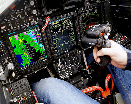
 The ability to receive current weather information in the cockpit is one of the most important safety advancements available for general aviation aircraft. Today’s pilot now has the option to receive in-cockpit / in-flight weather data using one of two major options:
- ADS-B In that uses uplinks from U.S. Government ADS-B Ground Stations; and
- Commercial weather services that use downlinks from private constellations of orbiting satellites.
There are major differences in the completeness and timeliness of ADS-B weather data versus the weather data delivered by commercial satellite services. You should understand these differences before selecting a weather solution that you’ll use to make safety-of-life decisions for yourself and your passengers. From the FAA’s perspective, all forms of in-flight weather data are for advisory purposes only and should not be used to replace official sources of weather briefing data such as Flight Services. Be sure to check with individual equipment and service providers for the latest details on product and service availability, as features, coverage areas, weather products, and reception areas/volumes change.
ADS-B In Ground Station Datalink Weather (FIS-B)
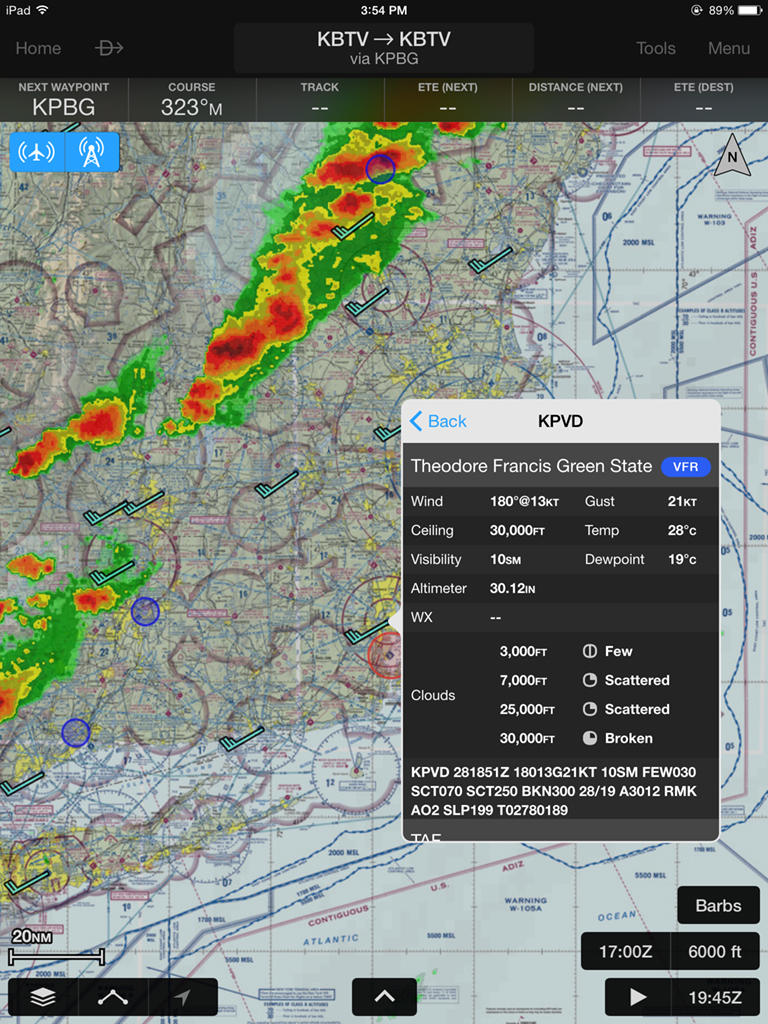
Garmin Pilot App ADS-B NEXRAD, Winds Aloft and METAR Display. Click to enlarge.
- Examples of a portable ADS-B Receiver would be the Garmin GDL 39 3D with built in WAAS GPS and AHRS.
- Examples of a permanently installed ADS-B Receivers would be the Garmin GDL 88 datalink or the Avidyne MLB100 Receiver.
Higher Please
 Because you’re receiving data from ADS-B ground stations, you generally need to be airborne in order to receive FIS-B broadcasts. The FAA lists coverages by phase of flight. En route coverage is contiguous throughout the lower 48 states, but in some cases you may need to be as high as 1,500 to 5,000 AGL to receive FIS-B. Terminal coverage is available at lower altitudes and is available when flying near approximately 235 major airports in the U.S. Surface coverage allows you to receive FIS-B while still on the ground and is available at approximately 36 major airports in the U.S. You can play with an FAA Interactive Coverage Map. In all usage scenarios, NexAir will optimize your ADS-B receiver antenna placement so as to maximize reception ranges and reliability.
“I Missed That”
 In general, because of inherit limitations to the system’s data bandwidth, ADS-B weather data will arrive later (which has caught some pilots off guard with delayed TFR updates), take longer to update (as long as 30-minutes for METARs after you first start receiving FIS-B data), contain less detail (NEXRAD imagery beyond 250 NM is much lower resolution), be missing some key information (such as satellite imagery), and supply limited data beyond your current location (TFRs are limited to a 100NM radius, while METARs, TAFs and NOTAMs are limited to 100 NM radius when FIS-B is delivered on the airport surface).
So be aware that the ADS-B weather data you see on the ground or in-flight may not be as current as you’d like, or be as complete as you’re used to when receiving an online briefing with your laptop. Shown below are the best case timings and ranges for ADS-B FIS-B data delivery, assuming ideal uninterrupted reception and reception ranges. Timings do not factor in the sweep of METAR data through the ADS-B system which can create delays as long as 30-minutes for the nationwide distribution of METAR data. Click to enlarge.
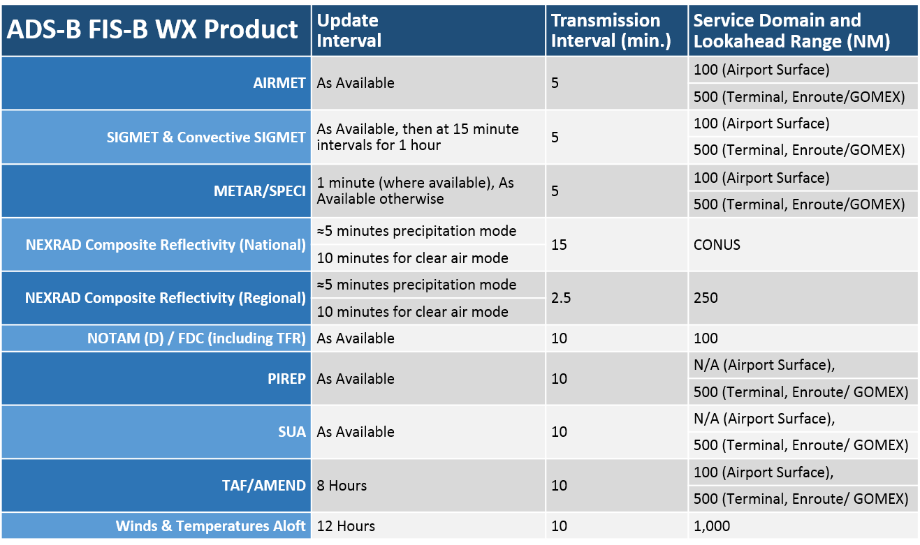
ADS-B Best Case FIS-B Timings and Ranges. Click to enlarge.
Satellite Datalink Weather
All of the Satellite Datalink Weather service providers described below deliver their broadcast signals from above, so you can receive all weather data from anywhere and any altitude where you have an unobstructed view of the sky — from the time you roll out of your hangar, to the time you tie down on the ramp at your destination, and everywhere in between.
SiriusXM Aviation Weather and XM WX Satellite Weather
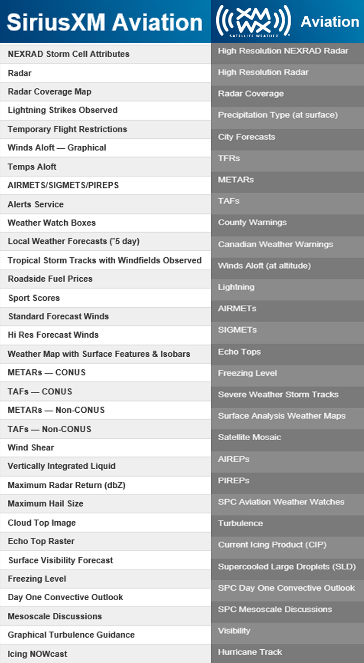
Comparison of SiriusXM versus XM WX. Click to enlarge.
SiriusXM Aviation Weather and XM WX Satellite Weather are sold by the same parent company, Sirius XM Radio Inc., but are slightly different services that require the use of different and incompatible satellite receivers. Each uses a private network of satellites in elliptical orbits that provide continuous signal coverage over the continental U.S, plus Alaska and Hawaii, and up to 200 miles of offshore coverage.
XM WX Satellite Weather is provided by Baron WxWorx. SiriusXM Aviation Weather weather data is provided by WSI, and has a larger coverage area than XM WX Satellite Weather, extending into northern Canada and south to Puerto Rico.
That Was Fast
The XM systems’ satellites deliver high bandwidth data, so they can provide high-resolution NEXRAD images throughout the U.S., at any distance from your plane. The rate at which your weather data will update after initial power on is very fast. You will not have to wait for METAR data to be rolled out nationwide, station by station, as you do with ADS-B; you’ll receive all available data within a few minutes of your SiriusXM or XM WX receiver coming into view of the satellites. That said, some users have reported delays related to METAR updates, so wether you’re using ADS-B or Satellite Datalink Weather, it’s always advisable to listen to the ATIS or AWOS radio broadcast as you near your destination.
Lots of Options
Both offer three pricing tiers with increasing levels of weather products added within each tier. Show to the right is a table you can click to enlarge that will show you what products are available with the highest priced version of each service. One key difference is that XM WX explicitly states that it includes Satellite Mosaic, where SiriusXM does not.
Buyer Beware
SiriusXM Aviation Weather is the newer of the two services, and some aviation journalists have called into question the future of XM WX Satellite Weather given that it’s redundant with SiriusXM, and that dropping it would free up valuable bandwidth for other programming content on the XM satellite constellation. For example, Garmin used to sell an optional GXM 40 XM WX receiver for the GPSMAP 696 and aera 796, but now only sells the GXM 42 receiver for SiriusXM. According to Sirius XM Radio Inc., both services will continue to be offered, but they have not committed to any sunset date for XM WX given the number of paid subscribers already using the legacy service. An online search also shows that you can still purchase the GXM 40 XM WX receiver from third-party sources.
Garmin Satellite Datalink Weather
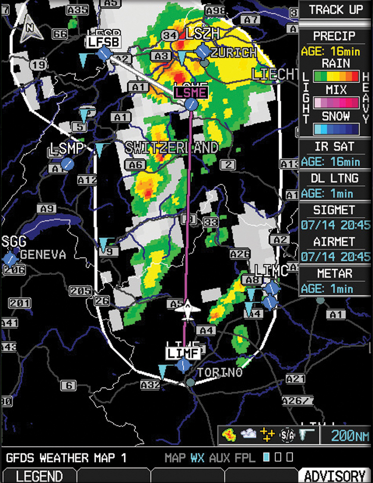
Garmin Flight Data Services (GFDS) Weather Data as displayed on the G600. Click to enlarge.
Garmin’s GSR 56 gives you access to on-demand global weather information and text/voice communications through the Iridium satellite network (subscription required). The Iridium network provides seamless global coverage nearly everywhere your aircraft can go — even in locations not previously served by Sirius XM Radio Inc., so you can use on-demand satellite weather when operating internationally. World Wide Weather data includes METARs (temperature, dew point, precipitation, wind speed and more), as well as TAFs that show weather forecasts up to 30 hours out. Throughout most of Europe, Canada and the U.S., the GSR 56 can receive high resolution radar imagery, which displays in full color on the G3000™, G1000® and G600, G500 and G500H series displays (radar coverage areas are being expanded). To limit satellite datalink usage, and therefore charges, updates are not pushed to your receiver; you must initiate a request to refresh the data, and the radar data sent is limited to areas surrounding your flight plan.
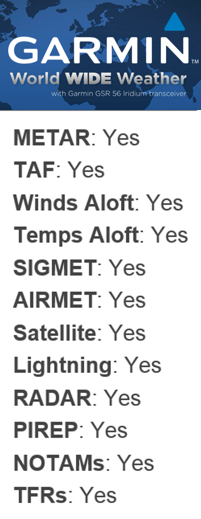
Garmin World Wide Weather products for the U.S. Click to enlarge.
Since the system is using the Iridium satellite network, the GSR 56 can make and accept telephone calls while in flight by integrating with your audio/intercom system using your aviation headsets.
If you have or install a G3000 or G1000, the GSR 56 can also be used to provide 2-way text messaging via SMS to any compatible phone or email address. For full details of the weather products provided, visit Garmin’s World Wide Weather page. You can also follow this link to watch a Garmin Marketing Video about their World Wide Weather product on YouTube.
Avidyne Satellite Datalink Weather
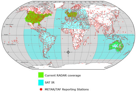
RADAR Coverage Map. Click to enlarge.
Avidyne’s MLX770 delivers aviation-quality weather data via the Iridium Satellite Network for display on Avidyne’s Entegra and EX500/EX5000-series multi-function displays. Utilizing the 66-satellite Iridium constellation, Avidyne’s exclusive Network Operations Center (NOC) and innovative two-way datalink transmission technology, the MLX770 delivers affordable datalink graphical weather for general aviation operations outside the continental United States (CONUS). Services include high-resolution Radar imagery, METARs, and TAFs, displayed in full color on your Avidyne MFD. You also now have access to the RADAR mosaic for virtually all of Western Europe, Australia, and parts of the United States. Weather products and coverage areas may be subject to change without notice, so please consult Avidyne’s MLX770 page for the latest information.
 The MLX770 receives TAFs, which give the predicted weather conditions expected at an aerodrome, usually for a 9 or 24 hour period.
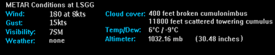 The MLX770 receives METARs, which give the actual weather conditions at an aerodrome at the time of the report. METARs are typically issued every 30-60 minutes.
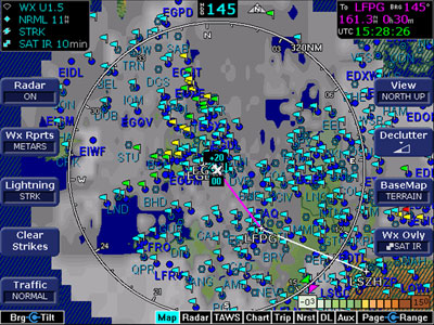
The MLX770 delivers SAT IR imagery for selected geographic regions. SAT IR imagery shows the emission from the infrared portion of the solar spectrum. Bright areas represent cold high cloud tops. Dark areas represent warm ground and ocean surfaces.
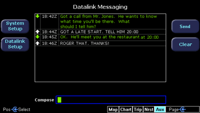
The MLX770 provides two-way text messaging from your airborne MFD via SMS text messaging to any ground-based SMS-capable mobile phones. Your family and friends can even send a text message to you in your airplane.
Lightning Detection Systems
 Many pilots that spend a lot of time flying IFR also like to have their own on-board lightning detection and display equipment. Lightning bolts produce radio waves called sferics. Lightning detection systems listen for sferics and then map them on an MFD or dedicated lightning display. These systems use a special antenna, receiver, and processor to detect the lightning and to determine its direction and distance from the aircraft. One key advantage of these systems is that they detect and display lightning immediately, in real-time, without any of the lags or delays associated with the collection and distribution of lightning data by ADS-B or satellite subscription weather distribution systems. Examples of add-on lightning detection systems include:
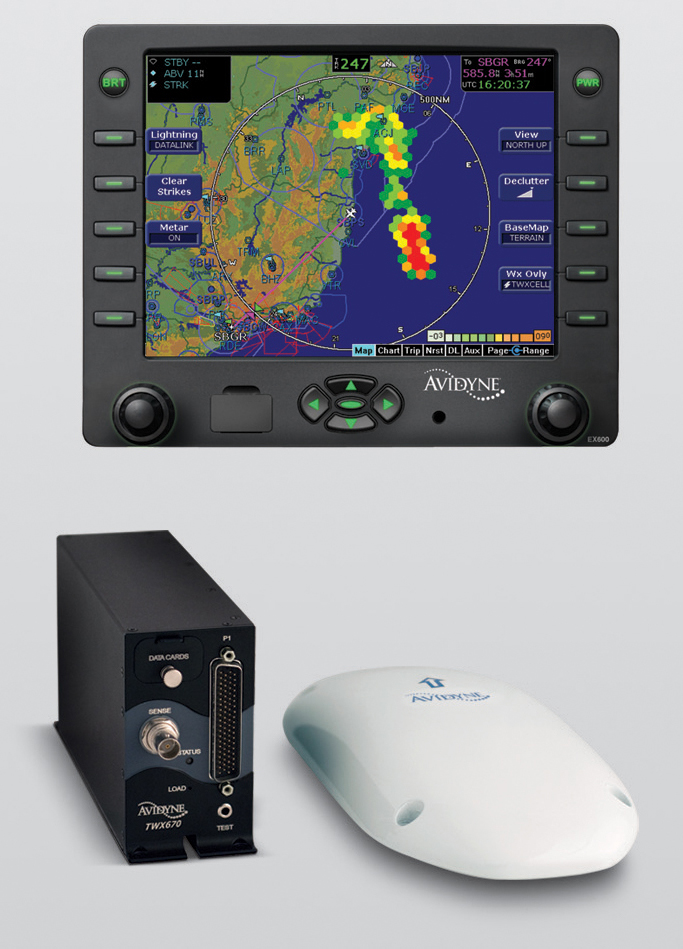
Avidyne’s TWX670 system displaying lightning on the Avidyne EX600 MFD with TwxCell Mode. Click to enlarge.
Avidyne’s TWX670 Tactical Weather Detection System is a third-generation lightning-based weather detection system that provides a simple and intuitive color-contoured display with instantaneous picture of surrounding weather. It’s the first and only lightning-based, real time, tactical, color, weather avoidance solution. It accurately detects and clearly displays electrical discharges — the primary indicator of thunderstorms — in real time, regardless of aircraft maneuvering. With its significantly improved accuracy over previous generation lightning detection systems, the TWX670 provides true tactical weather avoidance in the critical 0 – 25nm range, making it a perfect complement to the strategic benefits of satellite-based datalink weather. Output can be displayed on the Avidyne MHD300 (in TWxCell & Color Strike modes), Avidyne EX500/EX5000/EX600 MFD, and many popular 3rd-party displays such as the Garmin GNS 430 or 530 (in compatibility mode).
 Insight Avionics’ STRIKE FINDER® Digital Weather Avoidance System detects and analyzes the electrical activity emanating from thunderstorms within a 200 nautical mile (nm) radius of your aircraft. A dedicated display plots an accurate, reliable and easily-interpreted picture of electrical activity, that you can use to circumnavigate the hazards associated with thunderstorms. The STRIKE FINDER® can be slaved directly to an HSI or compass system with a standard stepper or synchro-output so that the display of lightning will be continuously reoriented relative to the aircraft’s flight path throughout any turn or maneuvers. Insight also offers an optional stabilization module that eliminates the need for a slaved compass system. You can zoom in or out as desired, animate the display to show the formation and migration of buildups, or clear the display to start accumulating strike data anew.
Airborne Weather Radar
NexAir can help you support your existing airborne weather radar system, or upgrade or replace your system if it’s no longer viable to keep it operating. Today’s modern weather radar systems are solid state and are much more reliable and capable than older legacy systems. Contact NexAir to learn more about airborne weather radar systems.

Garmin’s solid-state GWX 70 full-color Doppler-capable weather radar, shown here displaying on a GTN 750.
Shown above, Garmin’s GWX 70 airborne weather radar brings full-color storm cell tracking to your compatible Garmin MFD. This Doppler-capable weather avoidance tool combines excellent range and adjustable scanning profiles with precision target definition for accurate, easy-to-interpret, weather analysis in the cockpit. With pilot-adjustable horizontal scan angles of up to 120°, you can easily focus scanning on the areas you want to watch, while vertical scanning lets you focus on storm tops, gradients and cell buildup at various altitudes. Plus, Weather Attenuated Color Highlight (WATCH™) can identify areas beyond the radar’s capability that may contain even more hazardous areas of precipitation.
Start the Conversation
If you’ve seen something here that sparks your imagination, get the conversation started. Email Dave Fetherston, call him at 877-318-0975, or submit an online Request for Quote or Request Repairs or Maintenance short form. We’re ready to collaborate with you so that you, too, can have a smarter plane and be a smarter pilot.